googlemaps/android-maps-compose

Là một dự án di động, googlemaps/android-maps-compose đã đạt 1.3k sao trên GitHub, ngôn ngữ Kotlin. Jetpack Compose composables for the Maps SDK for Android
Tóm tắt dựng từ metadata GitHub của chính dự án — chưa có bài review TopGit. Trang sẽ tự động cập nhật khi bài review đầy đủ được xuất bản.
TopGit viết bài đầy đủ cho repo có nhiều sao nhất và được yêu cầu nhiều nhất. Trang này là snapshot trong thời gian chờ — xem README gốc ở tab READ ME.
Snapshot
Cộng tác viên hàng đầu
Xem cộng tác viên hàng đầu








Maps Compose 🗺
Description
This repository contains Jetpack Compose components for the Maps SDK for Android.
Requirements
- Android API level 21+
- Kotlin-enabled project
- Jetpack Compose-enabled project (see releases for the required version of Jetpack Compose)
- Sign up with Google Maps Platform
- A Google Maps Platform project with the Maps SDK for Android enabled
- An API key associated with the project above ... follow the API key instructions if you're new to the process
Installation
You no longer need to specify the Maps SDK for Android or its Utility Library as separate dependencies, since maps-compose and maps-compose-utils pull in the appropriate versions of these respectively.
dependencies {
    implementation 'com.google.maps.android:maps-compose:8.4.0' // {x-release-please-version}
    // Optionally, you can include the Compose utils library for Clustering,
    // Street View metadata checks, etc.
    implementation 'com.google.maps.android:maps-compose-utils:8.4.0' // {x-release-please-version}
    // Optionally, you can include the widgets library for ScaleBar, etc.
    implementation 'com.google.maps.android:maps-compose-widgets:8.4.0' // {x-release-please-version}
}
Sample App
This repository includes a sample app.
To run the demo app, ensure you've met the requirements above then:
- Open the
secrets.propertiesfile in your top-level directory, and then add the following code. Replace YOUR_API_KEY with your API key. Store your key in this file because secrets.properties is excluded from being checked into a version control system. If thesecrets.propertiesfile does not exist, create it in the same folder as thelocal.default.propertiesfile.MAPS_API_KEY=YOUR_API_KEY - Build and run
Documentation
See the documentation for a full list of classes and their methods.
Usage
Adding a map to your app looks like the following:
val singapore = LatLng(1.35, 103.87)
val cameraPositionState = rememberCameraPositionState {
    position = CameraPosition.fromLatLngZoom(singapore, 10f)
}
GoogleMap(
    modifier = Modifier.fillMaxSize(),
    cameraPositionState = cameraPositionState
)
Creating and configuring a map
Creating and configuring a map
Configuring the map can be done by passing a MapProperties object into the
GoogleMap composable, or for UI-related configurations, use MapUiSettings.
MapProperties and MapUiSettings should be your first go-to for configuring
the map. For any other configuration not present in those two classes, use
googleMapOptionsFactory to provide a GoogleMapOptions instance instead.
Typically, anything that can only be provided once (i.e. when the map is
created)—like map ID—should be provided via googleMapOptionsFactory.
// Set properties using MapProperties which you can use to recompose the map
var mapProperties by remember {
    mutableStateOf(
        MapProperties(maxZoomPreference = 10f, minZoomPreference = 5f)
    )
}
var mapUiSettings by remember {
    mutableStateOf(
        MapUiSettings(mapToolbarEnabled = false)
    )
}
Box(Modifier.fillMaxSize()) {
    GoogleMap(properties = mapProperties, uiSettings = mapUiSettings)
    Column {
        Button(onClick = {
            mapProperties = mapProperties.copy(
                isBuildingEnabled = !mapProperties.isBuildingEnabled
            )
        }) {
            Text(text = "Toggle isBuildingEnabled")
        }
        Button(onClick = {
            mapUiSettings = mapUiSettings.copy(
                mapToolbarEnabled = !mapUiSettings.mapToolbarEnabled
            )
        }) {
            Text(text = "Toggle mapToolbarEnabled")
        }
    }
}

// ...or initialize the map by providing a googleMapOptionsFactory
// This should only be used for values that do not recompose the map such as
// map ID.
GoogleMap(
    googleMapOptionsFactory = {
        GoogleMapOptions().mapId("MyMapId")
    }
)
Controlling a map's camera
Controlling a map's camera
Camera changes and updates can be observed and controlled via CameraPositionState.
Note: CameraPositionState is the source of truth for anything camera
related. So, providing a camera position in GoogleMapOptions will be
overridden by CameraPosition.
val singapore = LatLng(1.35, 103.87)
val cameraPositionState: CameraPositionState = rememberCameraPositionState {
    position = CameraPosition.fromLatLngZoom(singapore, 11f)
}
Box(Modifier.fillMaxSize()) {
  GoogleMap(cameraPositionState = cameraPositionState)
  Button(onClick = {
    // Move the camera to a new zoom level
    cameraPositionState.move(CameraUpdateFactory.zoomIn())
  }) {
      Text(text = "Zoom In")
  }
}
Remember that the map must load before any camera state can be set. If you are using a LaunchedEffect, you must wait until the map has been loaded:
@Composable
fun MapScreen() {
var mapLoaded by remember { mutableStateOf(false) }

    GoogleMap(
        modifier = Modifier.fillMaxSize(),
        onMapLoaded = { mapLoaded = true }
    )

    if (mapLoaded) {
        LaunchedEffect(Unit) {
            // here the camera operations
        }
    }
}
Drawing on a map
Drawing on a map
Drawing on the map, such as adding markers, can be accomplished by adding child
composable elements to the content of the GoogleMap.
GoogleMap(
    googleMapOptionsFactory = {
        GoogleMapOptions().mapId("DEMO_MAP_ID")
    },
    //...
) {
    AdvancedMarker(
        state = MarkerState(position = LatLng(-34, 151)),
        title = "Marker in Sydney"
    )
    AdvancedMarker(
        state = MarkerState(position = LatLng(35.66, 139.6)),
        title = "Marker in Tokyo"
    )
}
You can customize a marker by using PinConfig with an AdvancedMarker.
val state = MyState()

GoogleMap(
    googleMapOptionsFactory = {
        GoogleMapOptions().mapId("DEMO_MAP_ID")
    },
    //...
) {
    val pinConfig = PinConfig.builder()
        .setBackgroundColor(Color.MAGENTA)
        .build()

    AdvancedMarker(
        state = MarkerState(position = LatLng(-34, 151)),
        title = "Magenta marker in Sydney",
        pinConfig = pinConfig
    )
}
Shapes
Shapes
A shape is an object on the map, tied to a latitude/longitude coordinate. Currently, android-maps-compose offers Polyline, Polygon and Circle. For all shapes, you can customize their appearance by altering a number of properties.
Polyline
A Polyline is a series of connected line segments that can form any shape you want and can be used to mark paths and routes on the map:
val polylinePoints = remember { listOf(singapore, singapore5) }

// ...
Polyline(
    points = polylinePoints
)
You can use spans to individually color segments of a polyline, by creating StyleSpan objects:
val styleSpan = StyleSpan(
    StrokeStyle.gradientBuilder(
        Color.Red.toArgb(),
        Color.Green.toArgb(),
    ).build(),
)

// ...

val polylinePoints = remember { listOf(singapore, singapore5) }
val styleSpanList = remember { listOf(styleSpan) }

// ...

Polyline(
    points = polylinePoints,
    spans = styleSpanList,
)
Polygon
A Polygon is an enclosed shape that can be used to mark areas on the map:
val polygonPoints = remember { listOf(singapore1, singapore2, singapore3) }


// ...

Polygon(
    points = polygonPoints,
    fillColor = Color.Black.copy(alpha = 0.5f)
)
Circle
A Circle is a geographically accurate projection of a circle on the Earth's surface drawn on the map:
var circleCenter by remember { mutableStateOf(singapore) }

// ...

Circle(
    center = circleCenter,
    fillColor = MaterialTheme.colors.secondary,
    strokeColor = MaterialTheme.colors.secondaryVariant,
    radius = 1000.0,
)
Recomposing elements
Recomposing elements
Markers and other elements need to be recomposed in the screen. To achieve recomposition, you can set mutable properties of state objects:
val markerState = rememberUpdatedMarkerState(position = singapore)

//...

LaunchedEffect(Unit) {
    repeat(10) {
        delay(5.seconds)
        val old = markerState.position
        markerState.position = LatLng(old.latitude + 1.0, old.longitude + 2.0)
    }
}
In the example above, recomposition occurs as MarkerState.position is updated with different values over time, shifting the Marker around the screen.
Customizing a marker's info window
Customizing a marker's info window
You can customize a marker's info window contents by using the
MarkerInfoWindowContent element, or if you want to customize the entire info
window, use the MarkerInfoWindow element instead. Both of these elements
accept a content parameter to provide your customization in a composable
lambda expression.
MarkerInfoWindowContent(
    //...
) { marker ->
    Text(marker.title ?: "Default Marker Title", color = Color.Red)
}

MarkerInfoWindow(
    //...
) { marker ->
    // Implement the custom info window here
    Column {
        Text(marker.title ?: "Default Marker Title", color = Color.Red)
        Text(marker.snippet ?: "Default Marker Snippet", color = Color.Red)
    }
}
Street View
Street View
You can add a Street View given a location using the StreetView composable.
- Test whether a Street View location is valid with the the
fetchStreetViewDatautility from themaps-compose-utilslibrary.
 streetViewResult =
    fetchStreetViewData(singapore, BuildConfig.MAPS_API_KEY)
- Once the location is confirmed valid, add a Street View composable by providing a
StreetViewPanoramaOptionsobject.
val singapore = LatLng(1.3588227, 103.8742114)
StreetView(
    streetViewPanoramaOptionsFactory = {
        StreetViewPanoramaOptions().position(singapore)
    }
)
Controlling the map directly (experimental)
Controlling the map directly (experimental)
Certain use cases may require extending the GoogleMap object to decorate / augment
the map. It can be obtained with the MapEffect Composable.
Doing so can be dangerous, as the GoogleMap object is managed by this library.
GoogleMap(
    // ...
) {
    MapEffect { map ->
        // map is the GoogleMap
    }
}
Maps Compose Utility Library
This library provides optional utilities in the maps-compose-utils library from the Maps SDK for Android Utility Library.
Clustering
The marker clustering utility helps you manage multiple markers at different zoom levels. When a user views the map at a high zoom level, the individual markers show on the map. When the user zooms out, the markers gather together into clusters, to make viewing the map easier.
The MarkerClusteringActivity demonstrates usage.
Clustering(
    items = items,
    // Optional: Handle clicks on clusters, cluster items, and cluster item info windows
    onClusterClick = null,
    onClusterItemClick = null,
    onClusterItemInfoWindowClick = null,
    // Optional: Custom rendering for clusters
    clusterContent = null,
    // Optional: Custom rendering for non-clustered items
    clusterItemContent = null,
)
Street View metadata utility
The fetchStreetViewData method provides functionality to check whether a location is supported in StreetView. You can avoid errors when adding a Street View panorama to an Android app by calling this metadata utility and only adding a Street View panorama if the response is OK.
[!IMPORTANT] Be sure to enable Street View Static API on the project associated with your API key.
You can see example usage
in the StreetViewActivity of the demo app:
 streetViewResult =
    fetchStreetViewData(singapore, BuildConfig.MAPS_API_KEY)
Maps Compose Widgets
This library also provides optional composable widgets in the maps-compose-widgets library that you can use alongside the GoogleMap composable.
ScaleBar
This widget shows the current scale of the map in feet and meters when zoomed into the map, changing to miles and kilometers, respectively, when zooming out. A DisappearingScaleBar is also included, which appears when the zoom level of the map changes, and then disappears after a configurable timeout period.
The ScaleBarActivity demonstrates both of these, with the DisappearingScaleBar in the upper left corner and the normal base ScaleBar in the upper right:
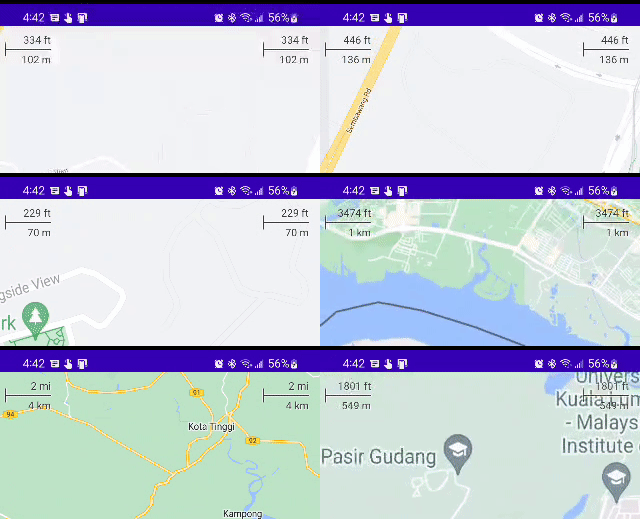
Both versions of this widget leverage the CameraPositionState in maps-compose and therefore are very simple to configure with their defaults:
Box(Modifier.fillMaxSize()) {

    GoogleMap(
        modifier = Modifier.fillMaxSize(),
        cameraPositionState = cameraPositionState
    ) {
        // ... your map composables ...
    }

    ScaleBar(
        modifier = Modifier
            .padding(top = 5.dp, end = 15.dp)
            .align(Alignment.TopEnd),
        cameraPositionState = cameraPositionState
    )

    // OR

    DisappearingScaleBar(
        modifier = Modifier
            .padding(top = 5.dp, end = 15.dp)
            .align(Alignment.TopStart),
        cameraPositionState = cameraPositionState
    )
}
The colors of the text, line, and shadow are also all configurable (e.g., based on isSystemInDarkTheme() on a dark map). Similarly, the DisappearingScaleBar animations can be configured.
Internal usage attribution ID
This library calls the addInternalUsageAttributionId method, which helps Google understand which libraries and samples are helpful to developers and is optional. Instructions for opting out of the identifier are provided below.
If you wish to disable this, you can do so by removing the initializer in your AndroidManifest.xml using the tools:node="remove" attribute:
<provider
    android:name="androidx.startup.InitializationProvider"
    android:authorities="${applicationId}.androidx-startup"
    android:exported="false"
    tools:node="merge">
    <meta-data
        android:name="com.google.maps.android.compose.utils.attribution.AttributionIdInitializer"
        tools:node="remove" />
</provider>
Contributing
Contributions are welcome and encouraged! If you'd like to contribute, send us a pull request and refer to our code of conduct and contributing guide.
Terms of Service
This library uses Google Maps Platform services. Use of Google Maps Platform services through this library is subject to the Google Maps Platform Terms of Service.
If your billing address is in the European Economic Area, effective on 8 July 2025, the Google Maps Platform EEA Terms of Service will apply to your use of the Services. Functionality varies by region. Learn more.
This library is not a Google Maps Platform Core Service. Therefore, the Google Maps Platform Terms of Service (e.g. Technical Support Services, Service Level Agreements, and Deprecation Policy) do not apply to the code in this library.
Support
This library is offered via an open source license. It is not governed by the Google Maps Platform Support Technical Support Services Guidelines, the SLA, or the Deprecation Policy. However, any Google Maps Platform services used by the library remain subject to the Google Maps Platform Terms of Service.
This library adheres to semantic versioning to indicate when backwards-incompatible changes are introduced. Accordingly, while the library is in version 0.x, backwards-incompatible changes may be introduced at any time.
If you find a bug, or have a feature request, please file an issue on GitHub. If you would like to get answers to technical questions from other Google Maps Platform developers, ask through one of our developer community channels. If you'd like to contribute, please check the contributing guide.
You can also discuss this library on our Discord server.
Repo liên quan
Free Programming Books (Chinese) is justjavac's GitHub index of free programming books, translated manuals, and course notes in Chinese, organized under headings like AI, Go, C/C++, and version control. It's a link list, not a curriculum - entries range from full book translations to single blog posts, some flagged `:worried:` for dead links, and contribution happens only through pull requests.
A meticulous HTTP client for the JVM, Android, and GraalVM.
Flutter is Google's open-source SDK, hosted at flutter/flutter on GitHub, for building user interfaces across mobile, web, and desktop from a single Dart codebase. The repo is licensed BSD-3-Clause, and its README documents stateful hot reload, a Skia/Impeller rendering pipeline, and Material/Cupertino widget sets as the core pieces developers work with.
scrcpy is an open-source application from Genymobile that mirrors an Android device's video and audio onto a Linux, Windows, or macOS desktop over USB or TCP/IP, and lets you control the device using the computer's keyboard and mouse. It runs without root access and without installing any companion app on the phone, per the README, and the project is available under an Apache-2.0 license.
Trả lời nhanh
Đọc thêm về googlemaps/android-maps-compose ở đâu?
Trang TopGit này là một snapshot — tab "Readme" hiển thị nguyên văn README của repo (đã bỏ link, giữ ảnh). Repo GitHub ở github.com/googlemaps/android-maps-compose là nguồn chính thức.
googlemaps/android-maps-compose có những chủ đề gì?
GitHub topics của googlemaps/android-maps-compose: "android", "google-maps", "jetpack-compose", "kotlin", "language-extension", "maps". TopGit xếp repo vào nhóm Mobile.
googlemaps/android-maps-compose có phải mã nguồn mở không?
Có — googlemaps/android-maps-compose phát hành theo license Apache-2.0, nghĩa là mã nguồn mở để đọc, fork và (tùy license) tái sử dụng. Mã: github.com/googlemaps/android-maps-compose.
googlemaps/android-maps-compose có trang demo không?
Dự án có trang chủ ở https://developers.google.com/maps/documentation/android-sdk/maps-compose. Tab "Readme" ở trang này thường có ảnh chụp và hướng dẫn bắt đầu nhanh.
googlemaps/android-maps-compose còn đang phát triển không?
Commit gần nhất trên googlemaps/android-maps-compose là 2 ngày trước (theo timestamp GitHub). Repo có 182 fork — một chỉ báo về mức độ quan tâm của cộng đồng.
googlemaps/android-maps-compose dùng license gì?
googlemaps/android-maps-compose phát hành theo license Apache-2.0. Nên mở file LICENSE trên GitHub để xác nhận — license metadata đôi khi lệch với thực tế dự án.
Đọc đầy đủ README ở tab phía trên.
android-maps-compose có đáng để bạn bỏ thời gian?
ChatGPT, Claude và Perplexity đều đọc được trang này. Hỏi thử xem họ nghĩ gì về android-maps-compose.